
Billing topographic map
Interactive map
Click on the map to display elevation.
About this map
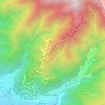
Name: Billing topographic map, elevation, terrain.
Location: Billing, Baijnath, Kangra, Himachal Pradesh, 176077, India (32.03843 76.72463 32.07843 76.76463)
Average elevation: 2,114 m
Minimum elevation: 1,477 m
Maximum elevation: 2,941 m
Other topographic maps
Click on a map to view its topography, its elevation and its terrain.
Deol
India > Himachal Pradesh > Baijnath
Deol, Baijnath, Kangra, Himachal Pradesh, India
Average elevation: 1,496 m
Utrala
India > Himachal Pradesh > Baijnath
Utrala, Baijnath, Kangra, Himachal Pradesh, India
Average elevation: 1,517 m
Sansal
India > Himachal Pradesh > Baijnath
Sansal, Baijnath, Kangra, Himachal Pradesh, 176077, India
Average elevation: 1,490 m
Bir
India > Himachal Pradesh > Baijnath
Bir, Baijnath, Kangra, Himachal Pradesh, 176077, India
Average elevation: 1,628 m