
Thank you for supporting this site ❤️
Make a donation
Make a donation
Hartford topographic map
Click on the map to display elevation.
Thank you for supporting this site ❤️
Make a donation
Make a donation
About this map
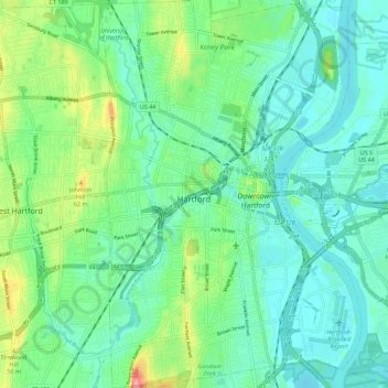
Name: Hartford topographic map, elevation, terrain.
Average elevation: 23 m
Minimum elevation: 0 m
Maximum elevation: 88 m
Thank you for supporting this site ❤️
Make a donation
Make a donation
Other topographic maps
Click on a map to view its topography, its elevation and its terrain.
Elizabeth Park
United States > Connecticut > Capitol Planning Region > West Hartford
Average elevation: 33 m