
Thank you for supporting this site ❤️
Make a donation
Make a donation
Saulnes topographic map
Click on the map to display elevation.
Thank you for supporting this site ❤️
Make a donation
Make a donation
About this map
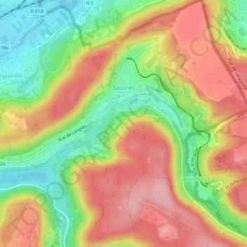
Name: Saulnes topographic map, elevation, terrain.
Average elevation: 338 m
Minimum elevation: 259 m
Maximum elevation: 409 m
Thank you for supporting this site ❤️
Make a donation
Make a donation
Other topographic maps
Click on a map to view its topography, its elevation and its terrain.
Bruly
France > Grand Est > Meurthe-et-Moselle > Bouvron > Ferme de la Charmotte
Average elevation: 220 m