
Gravesend topographic map
Interactive map
Click on the map to display elevation.
About this map
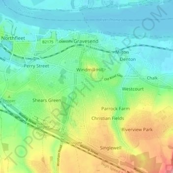
Name: Gravesend topographic map, elevation, terrain.
Location: Gravesend, Gravesham, Kent, England, United Kingdom (51.40741 0.35335 51.45201 0.43129)
Average elevation: 31 m
Minimum elevation: 0 m
Maximum elevation: 96 m
Other topographic maps
Click on a map to view its topography, its elevation and its terrain.
Vigo Village
United Kingdom > England > Kent > Gravesham
Vigo Village, Gravesham, Kent, England, DA13 0TD, United Kingdom
Average elevation: 144 m