Geolocate

Cranbourne East topographic map

Interactive map

Click on the map to display elevation.

About this map

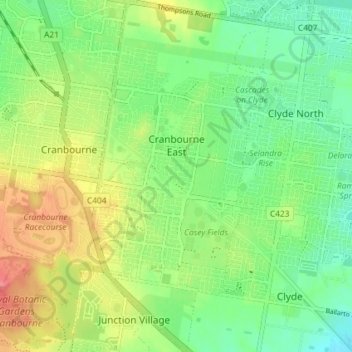
Name: Cranbourne East topographic map, elevation, terrain.

Location: Cranbourne East, Melbourne, City of Casey, Victoria, Australia (-38.14171 145.28824 -38.08451 145.32490)

Average elevation: 45 m

Minimum elevation: 17 m

Maximum elevation: 88 m

Other topographic maps

Click on a map to view its topography, its elevation and its terrain.

Mount Grand

Australia > Victoria > Melbourne

Average elevation: 80 m

Arthurs Seat

Australia > Victoria > Melbourne

Average elevation: 186 m

Wollert

Australia > Victoria > Melbourne

Average elevation: 191 m

Mornington District

Australia > Victoria > Melbourne

Average elevation: 50 m

Dandenong Ranges

Australia > Victoria > Melbourne

The topography consists of a series of ridges dissected by deeply cut streams. Sheltered gullies in the south of the range are home to temperate rain forest, fern gullies and Mountain Ash forest Eucalyptus regnans, whereas the drier ridges and exposed northern slopes are covered by dry sclerophyll forest of…

Average elevation: 456 m

Surrey Hills

Australia > Victoria > Melbourne

Average elevation: 96 m

Williamstown

Australia > Victoria > Melbourne

Average elevation: 4 m

Canterbury

Australia > Victoria > Melbourne

Average elevation: 78 m

Brighton

Australia > Victoria > Melbourne

Average elevation: 13 m

Chirnside Park

Australia > Victoria > Melbourne

Average elevation: 102 m

Maribyrnong River

Australia > Victoria > Melbourne

Average elevation: 60 m

Wattle Glen

Australia > Victoria > Melbourne > Wattle Glen

Average elevation: 121 m

Melbourne District

Australia > Victoria > Melbourne

Average elevation: 20 m

Tarneit District

Australia > Victoria > Melbourne

Average elevation: 45 m

Melbourne

Australia > Victoria > Melbourne

Melbourne is also prone to isolated convective showers forming when a cold pool crosses the state, especially if there is considerable daytime heating. These showers are often heavy and can include hail, squalls, and significant drops in temperature, but they often pass through very quickly with a rapid…

Average elevation: 49 m

Iramoo Wildlife Park

Australia > Victoria > Melbourne > Cairnlea

Average elevation: 63 m

Science Garden

Australia > Victoria > Melbourne > Meadow Heights

Average elevation: 174 m

Richmond

Australia > Victoria > Melbourne

Average elevation: 19 m

Glen Iris

Australia > Victoria > Melbourne

Average elevation: 46 m

Albert Park District

Australia > Victoria > Melbourne

Average elevation: 10 m