
Lake Ngarotoiti topographic map
Interactive map
Click on the map to display elevation.
About this map
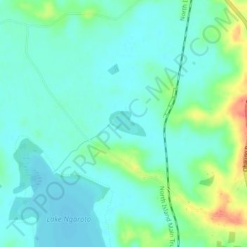
Name: Lake Ngarotoiti topographic map, elevation, terrain.
Average elevation: 49 m
Minimum elevation: 34 m
Maximum elevation: 92 m
Other topographic maps
Click on a map to view its topography, its elevation and its terrain.
Lake Ngaroto
New Zealand > Waikato > Ohaupo
Lake Ngaroto, Lake Ngaroto Walkway, Ohaupo, Waipa District, Waikato, New Zealand
Average elevation: 47 m
Lake Ruatuna
New Zealand > Waikato > Ohaupo
Lake Ruatuna, Ryburn Road, Ohaupo, Waipa District, Waikato, New Zealand
Average elevation: 51 m