
Σιδηρόκαστρο topographic map
Interactive map
Click on the map to display elevation.
About this map
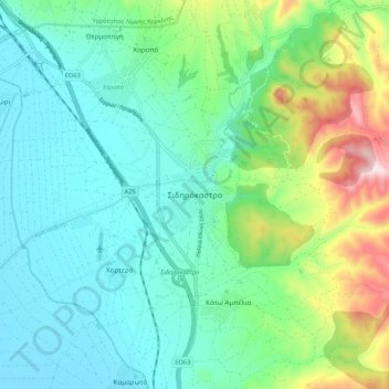
Name: Σιδηρόκαστρο topographic map, elevation, terrain.
Average elevation: 155 m
Minimum elevation: 35 m
Maximum elevation: 521 m
Other topographic maps
Click on a map to view its topography, its elevation and its terrain.
Provatas
Griechenland > Makedonien - Thrakien > Regionalbezirk Serres
Provatas, Δήμος Σερρών, Regionalbezirk Serres, Zentralmakedonien, Makedonien - Thrakien, 621 00, Griechenland
Average elevation: 18 m
Μαυροθάλασσα
Griechenland > Makedonien - Thrakien > Regionalbezirk Serres
Μαυροθάλασσα, Δήμος Βισαλτίας, Regionalbezirk Serres, Zentralmakedonien, Makedonien - Thrakien, 620 49, Griechenland
Average elevation: 30 m