
Thank you for supporting this site ❤️
Make a donation
Make a donation
Maraetai topographic map
Click on the map to display elevation.
Thank you for supporting this site ❤️
Make a donation
Make a donation
About this map
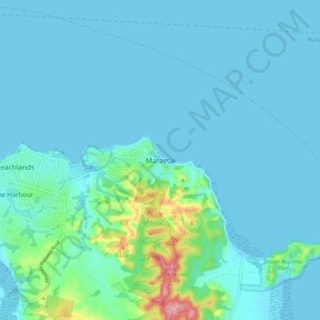
Name: Maraetai topographic map, elevation, terrain.
Location: Maraetai, Franklin, Auckland, 2018, New Zealand (-36.92075 175.00264 -36.84075 175.08264)
Average elevation: 22 m
Minimum elevation: 0 m
Maximum elevation: 185 m
Auckland trails, hiking, mountain biking, running and outdoor activities
Thank you for supporting this site ❤️
Make a donation
Make a donation