
Thank you for supporting this site ❤️
Make a donation
Make a donation
Kiel topographic map
Click on the map to display elevation.
Thank you for supporting this site ❤️
Make a donation
Make a donation
About this map
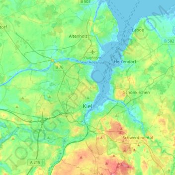
Name: Kiel topographic map, elevation, terrain.
Location: Kiel, Schleswig-Holstein, Germany (54.25071 10.03293 54.43294 10.21862)
Average elevation: 22 m
Minimum elevation: -4 m
Maximum elevation: 78 m
Thank you for supporting this site ❤️
Make a donation
Make a donation
Other topographic maps
Click on a map to view its topography, its elevation and its terrain.