
Baran topographic map
Click on the map to display elevation.
Baran
Baran is located at 25°06′N 76°31′E / 25.1°N 76.52°E / 25.1; 76.52. It has an average elevation of 262 metres (859 ft). It is surrounded by three Rivers Kalisindh, Parvati and Parban. The city is situated on the border of Rajasthan and Madhya Pradesh.
About this map
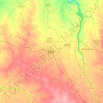
Name: Baran topographic map, elevation, terrain.
Location: Baran, Baran Tehsil, Baran District, Rajasthan, 325205, India (24.93819 76.35699 25.25819 76.67699)
Average elevation: 264 m
Minimum elevation: 212 m
Maximum elevation: 300 m