
Cheduba Island topographic map
Interactive map
Click on the map to display elevation.
Cheduba Island
Cheduba Island lies about 10 km (6 mi) from the southwestern coast of Ramree Island. It is located between 18° 40′ and 18° 56′ N. lat., and between 93° 31′ and 93° 50′ E. long. The terrain of the island is quite flat with scattered moderate elevations. The highest point 205 metres (673 ft) is on a ridge in the southwestern part of the island.
About this map
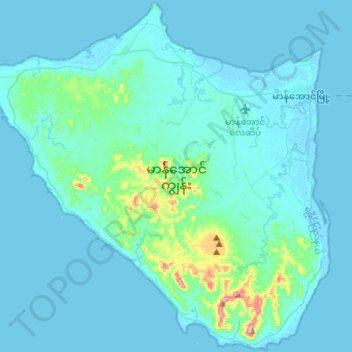
Name: Cheduba Island topographic map, elevation, terrain.
Location: Cheduba Island, Rakhine, Myanmar (18.66764 93.47894 18.92071 93.75015)
Average elevation: 17 m
Minimum elevation: -2 m
Maximum elevation: 212 m