
Thank you for supporting this site ❤️
Make a donation
Make a donation
Edgewater topographic map
Click on the map to display elevation.
Thank you for supporting this site ❤️
Make a donation
Make a donation
About this map
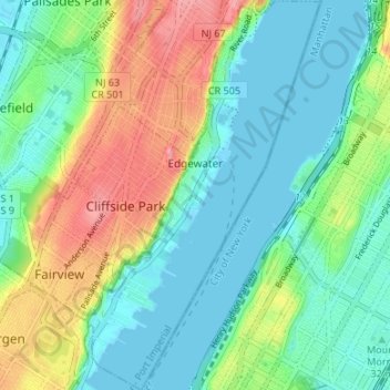
Name: Edgewater topographic map, elevation, terrain.
Location: Edgewater, Bergen County, New Jersey, 07020, United States (40.79749 -73.99441 40.84810 -73.95419)
Average elevation: 33 m
Minimum elevation: -1 m
Maximum elevation: 102 m
Thank you for supporting this site ❤️
Make a donation
Make a donation
Other topographic maps
Click on a map to view its topography, its elevation and its terrain.
Township of Washington
United States > New Jersey > Bergen County > Township of Washington
Average elevation: 37 m