
Sondernach topographic map
Interactive map
Click on the map to display elevation.
About this map
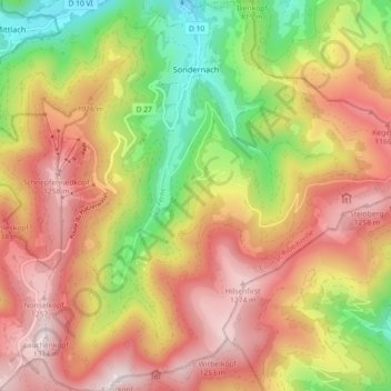
Name: Sondernach topographic map, elevation, terrain.
Average elevation: 931 m
Minimum elevation: 494 m
Maximum elevation: 1,314 m
Located in the parc naturel régional des Ballons des Vosges, the village of Sondernach shares with Mittlach the benefit of being situated on the slopes of a large valley watered by one of the streams forming the river Fecht. The altitude of the centre is between 500 and 600 metres.
Other topographic maps
Click on a map to view its topography, its elevation and its terrain.
68116
France > Grand Est > Haut-Rhin > Guewenheim
68116, Guewenheim, Thann-Guebwiller, Haut-Rhin, Grand Est, Metropolitan France, France
Average elevation: 341 m
Berrwiller
France > Grand Est > Haut-Rhin
Berrwiller, Mulhouse, Haut-Rhin, Grand Est, Metropolitan France, 68500, France
Average elevation: 271 m
Durlinsdorf
France > Grand Est > Haut-Rhin
Durlinsdorf, Altkirch, Haut-Rhin, Grand Est, Metropolitan France, 68480, France
Average elevation: 496 m
Schweighouse
France > Grand Est > Haut-Rhin > Lautenbach
Schweighouse, Lautenbach, Thann-Guebwiller, Haut-Rhin, Grand Est, Metropolitan France, 68610, France
Average elevation: 498 m
Lautenbach
France > Grand Est > Haut-Rhin
Lautenbach, Thann-Guebwiller, Haut-Rhin, Grand Est, Metropolitan France, 68610, France
Average elevation: 628 m
Soultzeren
France > Grand Est > Haut-Rhin
Soultzeren, Colmar-Ribeauvillé, Haut-Rhin, Grand Est, Metropolitan France, 68140, France
Average elevation: 843 m
Le Bonhomme
France > Grand Est > Haut-Rhin
Le Bonhomme, Colmar-Ribeauvillé, Haut-Rhin, Grand Est, Metropolitan France, 68650, France
Average elevation: 904 m
Wihr-au-Val
France > Grand Est > Haut-Rhin
Wihr-au-Val, Colmar-Ribeauvillé, Haut-Rhin, Grand Est, Metropolitan France, 68230, France
Average elevation: 485 m
Rimbach-près-Masevaux
France > Grand Est > Haut-Rhin
Rimbach-près-Masevaux, Thann-Guebwiller, Haut-Rhin, Grand Est, Metropolitan France, 68290, France
Average elevation: 775 m
Bourbach-le-Haut
France > Grand Est > Haut-Rhin
Bourbach-le-Haut, Thann-Guebwiller, Haut-Rhin, Grand Est, Metropolitan France, 68290, France
Average elevation: 701 m
Le Markstein
France > Grand Est > Haut-Rhin > Fellering
Le Markstein, Fellering, Thann-Guebwiller, Haut-Rhin, Grand Est, Metropolitan France, 68470, France
Average elevation: 1,013 m
Muhlbach-sur-Munster
France > Grand Est > Haut-Rhin
Muhlbach-sur-Munster, Colmar-Ribeauvillé, Haut-Rhin, Grand Est, Metropolitan France, 68380, France
Average elevation: 642 m
Neuf-Brisach
France > Grand Est > Haut-Rhin
Neuf-Brisach, Colmar-Ribeauvillé, Haut-Rhin, Grand Est, Metropolitan France, 68600, France
Average elevation: 195 m
Saint-Bernard
France > Grand Est > Haut-Rhin
Saint-Bernard, Altkirch, Haut-Rhin, Grand Est, Metropolitan France, 68720, France
Average elevation: 284 m
Schaeferhof
France > Grand Est > Haut-Rhin > Kembs
Schaeferhof, Kembs, Mulhouse, Haut-Rhin, Grand Est, Metropolitan France, 68680, France
Average elevation: 247 m
Katzenthal
France > Grand Est > Haut-Rhin > Katzenthal
Katzenthal, Colmar-Ribeauvillé, Haut-Rhin, Grand Est, Metropolitan France, 68230, France
Average elevation: 293 m
Wildenstein
France > Grand Est > Haut-Rhin
Wildenstein, Thann-Guebwiller, Haut-Rhin, Grand Est, Metropolitan France, 68820, France
Average elevation: 973 m
Breitenbach-Haut-Rhin
France > Grand Est > Haut-Rhin
Breitenbach-Haut-Rhin, Colmar-Ribeauvillé, Haut-Rhin, Grand Est, Metropolitan France, 68380, France
Average elevation: 677 m
Guebwiller
France > Grand Est > Haut-Rhin
Guebwiller, Thann-Guebwiller, Haut-Rhin, Grand Est, Metropolitan France, 68500, France
Average elevation: 379 m