
San Vicente topographic map
Interactive map
Click on the map to display elevation.
About this map
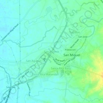
Name: San Vicente topographic map, elevation, terrain.
Location: San Vicente, Bulacan, Central Luzon, 3011, Philippines (15.12182 120.94887 15.16182 120.98887)
Average elevation: 18 m
Minimum elevation: 11 m
Maximum elevation: 36 m
Other topographic maps
Click on a map to view its topography, its elevation and its terrain.
Pandi
Pandi is rich in many natural brooks coming from the mainland itself. In some remote areas the lands are still covered by bamboo trees that naturally thrive and multiplies. Some lands privately owned have mango plantations. In some areas that are privately owned are rock deposits being used for housing…
Average elevation: 30 m
Pulilan
The municipality is generally of flat topography. Eleven (11) of its barangays are bounded by the Angat River. The rest are flat irrigated rice lands. Soil types vary from sandy loam to clay loam which makes the municipality suitable to a wide range of agricultural products.[10]
Average elevation: 10 m
Doña Remedios Trinidad
List of highest peaks in D.R.T by elevation.
Average elevation: 172 m