
Thank you for supporting this site ❤️
Make a donation
Make a donation
Valhelhas topographic map
Click on the map to display elevation.
Thank you for supporting this site ❤️
Make a donation
Make a donation
About this map
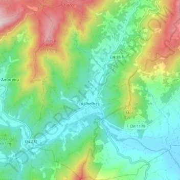
Name: Valhelhas topographic map, elevation, terrain.
Location: Valhelhas, Guarda, Portugal (40.38061 -7.43149 40.44263 -7.36550)
Average elevation: 691 m
Minimum elevation: 471 m
Maximum elevation: 1,173 m
Thank you for supporting this site ❤️
Make a donation
Make a donation
Other topographic maps
Click on a map to view its topography, its elevation and its terrain.