
Thank you for supporting this site ❤️
Make a donation
Make a donation
Limestone County topographic map
Click on the map to display elevation.
Thank you for supporting this site ❤️
Make a donation
Make a donation
About this map
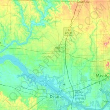
Name: Limestone County topographic map, elevation, terrain.
Location: Limestone County, Alabama, United States (34.55078 -87.28091 34.99901 -86.78359)
Average elevation: 209 m
Minimum elevation: 165 m
Maximum elevation: 377 m
Thank you for supporting this site ❤️
Make a donation
Make a donation
Other topographic maps
Click on a map to view its topography, its elevation and its terrain.