
Make a donation
Afing - Avigna topographic map
Click on the map to display elevation.
Make a donation
About this map
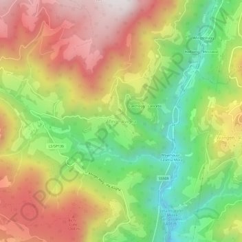
Name: Afing - Avigna topographic map, elevation, terrain.
Average elevation: 955 m
Minimum elevation: 430 m
Maximum elevation: 1,515 m
Make a donation
Other topographic maps
Click on a map to view its topography, its elevation and its terrain.
Afers - Eores
Italy > Trentino – Alto Adige/Südtirol > South Tyrol > Brixen - Bressanone
Average elevation: 1,632 m
Seiser Alm-Gruppe - Gruppo Mont de Sëuc - Gruppo dell'Alpe di Siusi
Italy > Trentino – Alto Adige/Südtirol > South Tyrol > Kastelruth - Castelrotto
Seiser Alm (Italian: Alpe di Siusi, Ladin: Mont Sëuc) is a Dolomite plateau and the largest high-elevation Alpine meadow (German: Alm) in Europe. Located in Italy's South Tyrol province in the Dolomites mountain range, it is a major tourist attraction, notably for skiing and hiking.
Average elevation: 1,466 m
Albeins - Albes
Italy > Trentino – Alto Adige/Südtirol > South Tyrol > Brixen - Bressanone
Average elevation: 729 m
Make a donation
St. Anton
Italy > Trentino – Alto Adige/Südtirol > South Tyrol > Völs am Schlern - Fiè allo Sciliar
Average elevation: 804 m
Make a donation
Eppan an der Weinstraße - Appiano sulla Strada del Vino
Italy > Trentino – Alto Adige/Südtirol > South Tyrol
Average elevation: 701 m
Hafling - Avelengo
Italy > Trentino – Alto Adige/Südtirol > South Tyrol
The emblem is a natural breed Haflinger horse on a mountain with three vert peaks, through a pine tree. The mountain and the pine symbolize that the village is located at high elevation. The coat of arms was granted in 1967.
Average elevation: 1,228 m
Pfitsch - Val di Vizze
Italy > Trentino – Alto Adige/Südtirol > South Tyrol
Average elevation: 1,953 m
Make a donation