
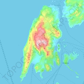
Lefkada topographic map
Interactive map
Click on the map to display elevation.
About this map
Name: Lefkada topographic map, elevation, terrain.
Average elevation: 111 m
Minimum elevation: -2 m
Maximum elevation: 1,160 m
Auf Lefkada gibt es keinen Massentourismus vom Muster Kretas oder der Balearischen Inseln. An der Ostküste sind die Städte Lefkada, direkt an der Brücke zum Festland gelegen, und Nydri (auch Nidri), etwa auf halber Höhe, die aktivsten Touristenzentren. An der Westküste sind die beiden Strände Porto Katsiki und Kathisma ein beliebtes Ausflugsziel, vor allem auch bei der einheimischen Bevölkerung. Trotz des Tourismus haben viele Orte noch ihren ursprünglichen Charakter behalten, vor allem die Dörfer in den Bergen.
Other topographic maps
Click on a map to view its topography, its elevation and its terrain.
Kalavros
Griechenland > Peloponnes, Westgriechenland und Ionische Inseln > Regionalbezirk Lefkada > Δημοτική Ενότητα Λευκάδος
Kalavros, Δημοτική Ενότητα Λευκάδος, Δήμος Λευκάδας, Regionalbezirk Lefkada, Region der Ionischen Inseln, Peloponnes, Westgriechenland und Ionische Inseln, 311 00, Griechenland
Average elevation: 224 m
Kalamitsi
Griechenland > Peloponnes, Westgriechenland und Ionische Inseln > Regionalbezirk Lefkada > Δημοτική Ενότητα Λευκάδος
Kalamitsi, Δημοτική Ενότητα Λευκάδος, Δήμος Λευκάδας, Regionalbezirk Lefkada, Region der Ionischen Inseln, Peloponnes, Westgriechenland und Ionische Inseln, 310 80, Griechenland
Average elevation: 333 m
Chortata
Griechenland > Peloponnes, Westgriechenland und Ionische Inseln > Regionalbezirk Lefkada > Δημοτική Ενότητα Απολλωνίων
Chortata, Δημοτική Ενότητα Απολλωνίων, Δήμος Λευκάδας, Regionalbezirk Lefkada, Region der Ionischen Inseln, Peloponnes, Westgriechenland und Ionische Inseln, 310 82, Griechenland
Average elevation: 648 m
Pinakochori
Griechenland > Peloponnes, Westgriechenland und Ionische Inseln > Regionalbezirk Lefkada > Δημοτική Ενότητα Σφακιωτών
Pinakochori, Δημοτική Ενότητα Σφακιωτών, Δήμος Λευκάδας, Regionalbezirk Lefkada, Region der Ionischen Inseln, Peloponnes, Westgriechenland und Ionische Inseln, 310 80, Griechenland
Average elevation: 452 m