
Hazelbrook topographic map
Click on the map to display elevation.
Hazelbrook
Hazelbrook is a town in New South Wales, Australia (Elevation: 675 metres) It is located 91 kilometres west of Sydney and 16 kilometres east of Katoomba in the Blue Mountains on the Great Western Highway.
About this map
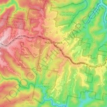
Name: Hazelbrook topographic map, elevation, terrain.
Average elevation: 610 m
Minimum elevation: 439 m
Maximum elevation: 771 m
Other topographic maps
Click on a map to view its topography, its elevation and its terrain.