
Thank you for supporting this site ❤️
Make a donation
Make a donation
Minimum topographic map
Click on the map to display elevation.
Thank you for supporting this site ❤️
Make a donation
Make a donation
About this map
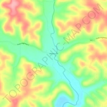
Name: Minimum topographic map, elevation, terrain.
Location: Minimum, Iron County, Missouri, 63620, United States (37.35616 -90.60762 37.39616 -90.56762)
Average elevation: 228 m
Minimum elevation: 170 m
Maximum elevation: 290 m
Thank you for supporting this site ❤️
Make a donation
Make a donation
Other topographic maps
Click on a map to view its topography, its elevation and its terrain.
Bell Mountain Wilderness
United States > Missouri > Iron County
The United States Congress designated the Bell Mountain Wilderness in 1980. The wilderness area now has a total of 9,027 acres (36.53 km2). Bell Mountain is located within the Potosi-Fredericktown Ranger District of the Mark Twain National Forest, south of Potosi, Missouri in the United States. The wilderness…
Average elevation: 374 m