Palale topographic map
Interactive map
Click on the map to display elevation.
About this map
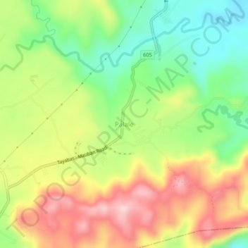
Name: Palale topographic map, elevation, terrain.
Location: Palale, Tayabas, Calabarzon, 4327, Philippines (14.02866 121.65244 14.06866 121.69244)
Average elevation: 182 m
Minimum elevation: 49 m
Maximum elevation: 337 m
Other topographic maps
Click on a map to view its topography, its elevation and its terrain.
Mount Banahaw
The andesitic Banahaw volcanic complex is composed of several stratovolcanoes with Mount Banahaw, the largest with a maximum elevation of 2,170 metres (7,119 ft) above mean sea level. The summit is topped by a 1.5 by 3.5 kilometres (0.93 mi × 2.17 mi) and 210 metres (690 ft) deep crater that is breached on…
Average elevation: 1,730 m