
Thank you for supporting this site ❤️
Make a donation
Make a donation
Danese topographic map
Click on the map to display elevation.
Thank you for supporting this site ❤️
Make a donation
Make a donation
About this map
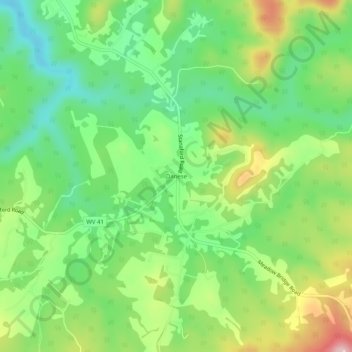
Name: Danese topographic map, elevation, terrain.
Location: Danese, Fayette County, West Virginia, United States (37.91067 -80.92315 37.95067 -80.88315)
Average elevation: 817 m
Minimum elevation: 731 m
Maximum elevation: 956 m
Thank you for supporting this site ❤️
Make a donation
Make a donation
Other topographic maps
Click on a map to view its topography, its elevation and its terrain.
New River Gorge National Park
United States > West Virginia > Fayette County > Fayetteville
Average elevation: 655 m
New River Gorge National Park and Preserve
United States > West Virginia > Fayette County > Oak Hill
Average elevation: 694 m
Thank you for supporting this site ❤️
Make a donation
Make a donation
Thank you for supporting this site ❤️
Make a donation
Make a donation
New River Gorge National Park
United States > West Virginia > Fayette County > Fayetteville
Average elevation: 655 m
Thank you for supporting this site ❤️
Make a donation
Make a donation