
Thank you for supporting this site ❤️
Make a donation
Make a donation
Greenbank topographic map
Click on the map to display elevation.
Thank you for supporting this site ❤️
Make a donation
Make a donation
About this map
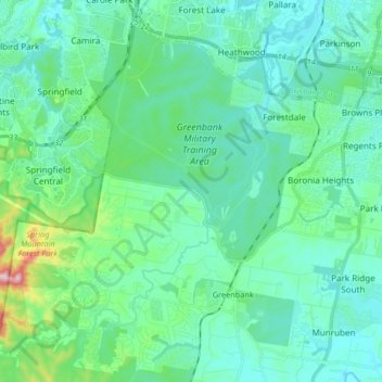
Name: Greenbank topographic map, elevation, terrain.
Location: Greenbank, Logan City, Queensland, Australia (-27.75598 152.87334 -27.62867 153.03834)
Average elevation: 62 m
Minimum elevation: 9 m
Maximum elevation: 322 m
Thank you for supporting this site ❤️
Make a donation
Make a donation
Other topographic maps
Click on a map to view its topography, its elevation and its terrain.