
West Jordan topographic map
Interactive map
Click on the map to display elevation.
About this map
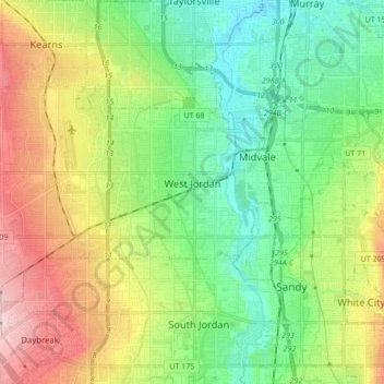
Name: West Jordan topographic map, elevation, terrain.
Location: West Jordan, Salt Lake County, Utah, United States (40.56594 -112.08259 40.64014 -111.91174)
Average elevation: 1,372 m
Minimum elevation: 1,296 m
Maximum elevation: 1,507 m
West Jordan is a city in Salt Lake County, Utah, United States. It is a suburb of Salt Lake City. According to the 2020 Census, the city had a population of 116,961, placing it as the third most populous in the state. The city occupies the southwest end of the Salt Lake Valley at an elevation of 4,330 feet (1,320 m). Named after the nearby Jordan River, the limits of the city begin on the river's western bank and end in the eastern foothills of the Oquirrh Mountains, where Kennecott Copper Mine, the world's largest man-made excavation, is located.
Other topographic maps
Click on a map to view its topography, its elevation and its terrain.
Salt Lake City
United States > Utah > Salt Lake County > Salt Lake City
Salt Lake City, Salt Lake County, Utah, 84139, United States
Average elevation: 1,625 m
Torry Pines
United States > Utah > Salt Lake County > Sandy
Torry Pines, Sandy, Salt Lake County, Utah, 84070, United States
Average elevation: 1,373 m
Sandy Heights South
United States > Utah > Salt Lake County > Sandy
Sandy Heights South, Sandy, Salt Lake County, Utah, 84070, United States
Average elevation: 1,371 m
Salt Lake County
United States > Utah > Salt Lake County
Salt Lake County, Utah, United States
Average elevation: 1,811 m