
Opsterland topographic map
Interactive map
Click on the map to display elevation.
About this map
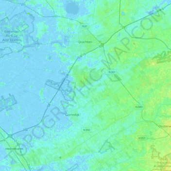
Name: Opsterland topographic map, elevation, terrain.
Location: Opsterland, Friesland, Netherlands (52.96436 5.92758 53.12921 6.33206)
Average elevation: 2 m
Minimum elevation: -5 m
Maximum elevation: 13 m
Dutch Topographic map of the municipality of Opsterland, June 2015
Other topographic maps
Click on a map to view its topography, its elevation and its terrain.
Dokkum
Netherlands > Friesland > Dokkum
Dokkum, Noardeast-Fryslân, Friesland, Netherlands
Average elevation: 0 m
Sneek
Netherlands > Friesland > Sneek
Sneek, Súdwest-Fryslân, Friesland, Netherlands
Average elevation: 0 m
Hallum
Netherlands > Friesland > Noardeast-Fryslân
Hallum, Noardeast-Fryslân, Friesland, Netherlands
Average elevation: -1 m