
Mbombela (Nelspruit) topographic map
Interactive map
Click on the map to display elevation.
About this map
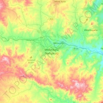
Name: Mbombela (Nelspruit) topographic map, elevation, terrain.
Average elevation: 833 m
Minimum elevation: 488 m
Maximum elevation: 1,398 m
Nelspruit Airport, located about 9 km (6 mi) south west of the city, is the city's original airport owned and operated by the municipality. There are over a hundred aircraft based at the airport. The majority of the aircraft are privately owned but there are several commercial aircraft based here as well. There are several AMO, fire fighting, charter & training companies based at the airport. The airport is limited in its potential operations by its runway length of 875 m (2870 ft). The topography of the area prohibits expansion.