
Make a donation
Ashland topographic map
Click on the map to display elevation.
Make a donation
About this map
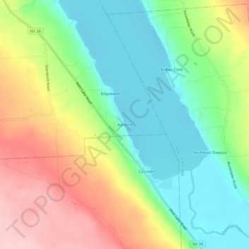
Name: Ashland topographic map, elevation, terrain.
Average elevation: 294 m
Minimum elevation: 209 m
Maximum elevation: 419 m
Make a donation
Other topographic maps
Click on a map to view its topography, its elevation and its terrain.
Cayuga Lake
United States > New York > Cayuga County > Village of Union Springs
Average elevation: 264 m
Make a donation
Make a donation
Make a donation
Make a donation
Make a donation
Fillmore Glen State Park
United States > New York > Cayuga County > Village of Moravia
Average elevation: 416 m
Owasco Lake
United States > New York > Cayuga County > Town of Niles
Owasco Lake is 11.1 miles (17.9 km) long, with a maximum width of 1.3 miles (2.1 km). The lake reaches a maximum depth of 177 feet (54 m) and has a surface elevation of 712 feet (217 m) above sea level, controlled by a dam on the lake's outlet. The lake has a volume of 212 billion US gallons (800,000,000 m3),…
Average elevation: 305 m
Make a donation
Make a donation