
Thank you for supporting this site ❤️
Make a donation
Make a donation
Boothbay topographic map
Click on the map to display elevation.
Thank you for supporting this site ❤️
Make a donation
Make a donation
About this map
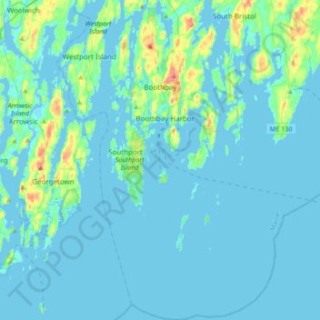
Name: Boothbay topographic map, elevation, terrain.
Location: Boothbay, Lincoln County, Maine, United States (43.69982 -69.69193 43.94135 -69.51416)
Average elevation: 9 m
Minimum elevation: -2 m
Maximum elevation: 83 m
Thank you for supporting this site ❤️
Make a donation
Make a donation
Other topographic maps
Click on a map to view its topography, its elevation and its terrain.