
Thank you for supporting this site ❤️
Make a donation
Make a donation
Boyne Falls topographic map
Click on the map to display elevation.
Thank you for supporting this site ❤️
Make a donation
Make a donation
About this map
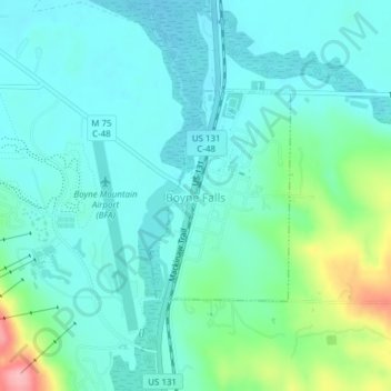
Name: Boyne Falls topographic map, elevation, terrain.
Location: Boyne Falls, Charlevoix County, Michigan, United States (45.16088 -84.92063 45.17541 -84.90685)
Average elevation: 231 m
Minimum elevation: 202 m
Maximum elevation: 339 m
Thank you for supporting this site ❤️
Make a donation
Make a donation
Other topographic maps
Click on a map to view its topography, its elevation and its terrain.
Charlevoix South Pier Light
United States > Michigan > Charlevoix County > Charlevoix
Average elevation: 180 m
Boyne Mountain
United States > Michigan > Charlevoix County > Boyne Valley Township
Average elevation: 263 m
Boyne Mountain
United States > Michigan > Charlevoix County > Boyne Valley Township
Average elevation: 263 m
Thank you for supporting this site ❤️
Make a donation
Make a donation