
Kandestederne topographic map
Interactive map
Click on the map to display elevation.
About this map
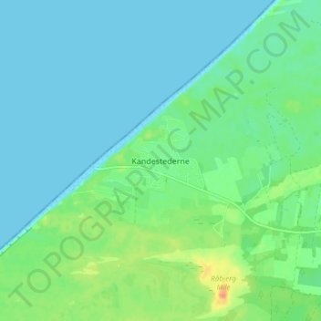
Name: Kandestederne topographic map, elevation, terrain.
Average elevation: 9 m
Minimum elevation: 0 m
Maximum elevation: 36 m
Other topographic maps
Click on a map to view its topography, its elevation and its terrain.
Ræhr
Ræhr, Thisted Kommune, Region Nordjütland, 7730, Dänemark
Average elevation: 26 m
Allingdam
Allingdam, Hjørring Kommune, Region Nordjütland, Dänemark
Average elevation: 34 m
Barkholt
Barkholt, Hjørring Kommune, Region Nordjütland, 9881, Dänemark
Average elevation: 15 m
Ejersted
Ejersted, Jammerbugt Kommune, Region Nordjütland, 9493, Dänemark
Average elevation: 12 m
Vrå
Vrå, Hjørring Kommune, Region Nordjütland, 9760, Dänemark
Average elevation: 22 m
Skibsted
Skibsted, Rebild Kommune, Region Nordjütland, 9293, Dänemark
Average elevation: 33 m
Byrum
Byrum, Læsø Kommune, Region Nordjütland, 9940, Dänemark
Average elevation: 4 m
Hjallerup
Hjallerup, Brønderslev Kommune, Region Nordjütland, 9320, Dänemark
Average elevation: 20 m
Kettrup
Kettrup, Jammerbugt Kommune, Region Nordjütland, 9493, Dänemark
Average elevation: 11 m
Nordjütische Insel
Nordjütische Insel, Brønderslev Kommune, Region Nordjütland, Dänemark
Average elevation: 9 m
Skagen
Skagen, Frederikshavn Kommune, Region Nordjütland, 9990, Dänemark
Average elevation: 1 m
Aalborg
Aalborg, Aalborg Kommune, Region Nordjütland, 9000, Dänemark
Average elevation: 17 m
Pandrup
Dänemark > Region Nordjütland > Pandrup
Pandrup, Jammerbugt Kommune, Region Nordjütland, 9490, Dänemark
Average elevation: 8 m
Hirtshals
Hirtshals, Hjørring Kommune, Region Nordjütland, 9850, Dänemark
Average elevation: 9 m
Jammerbugt Kommune
Jammerbugt Kommune, Region Nordjütland, Dänemark
Average elevation: 11 m
Thisted Kommune
Thisted Kommune, Region Nordjütland, Dänemark
Average elevation: 8 m
Saltum
Saltum, Jammerbugt Kommune, Region Nordjütland, 9493, Dänemark
Average elevation: 17 m
Thisted
Dänemark > Region Nordjütland > Thisted
Thisted, Thisted Kommune, Region Nordjütland, Dänemark
Average elevation: 17 m
Blokhus
Dänemark > Region Nordjütland > Blokhus
Blokhus, Jammerbugt Kommune, Region Nordjütland, 9492, Dänemark
Average elevation: 8 m
Kokkedal Slot
Dänemark > Region Nordjütland > Attrup
Kokkedal Slot, Kokkedalsvej, Attrup, Jammerbugt Kommune, Region Nordjütland, Dänemark
Average elevation: 16 m
Skørping
Dänemark > Region Nordjütland > Skørping
Skørping, Rebild Kommune, Region Nordjütland, Dänemark
Average elevation: 61 m
Brovst
Brovst, Jammerbugt Kommune, Region Nordjütland, 9460, Dänemark
Average elevation: 5 m
Vejby
Dänemark > Region Nordjütland > Vejby
Vejby, Hjørring Kommune, Region Nordjütland, Dänemark
Average elevation: 15 m