
Thank you for supporting this site ❤️
Make a donation
Make a donation
Mount Saint Paul topographic map
Click on the map to display elevation.
Thank you for supporting this site ❤️
Make a donation
Make a donation
About this map
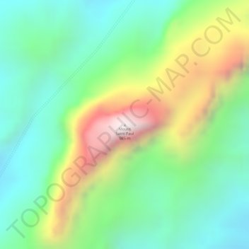
Name: Mount Saint Paul topographic map, elevation, terrain.
Location: Mount Saint Paul, Puerto Princesa, Mimaropa, Philippines (10.16266 118.90833 10.16276 118.90843)
Average elevation: 444 m
Minimum elevation: 117 m
Maximum elevation: 1,001 m
Thank you for supporting this site ❤️
Make a donation
Make a donation
Other topographic maps
Click on a map to view its topography, its elevation and its terrain.