
Thank you for supporting this site ❤️
Make a donation
Make a donation
Pedro Vera topographic map
Click on the map to display elevation.
Thank you for supporting this site ❤️
Make a donation
Make a donation
About this map
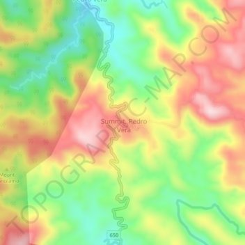
Name: Pedro Vera topographic map, elevation, terrain.
Location: Pedro Vera, Catanduanes, Bicol Region, 4805, Philippines (13.79118 124.24395 13.83118 124.28395)
Average elevation: 167 m
Minimum elevation: 24 m
Maximum elevation: 442 m
Thank you for supporting this site ❤️
Make a donation
Make a donation
Other topographic maps
Click on a map to view its topography, its elevation and its terrain.