
Caldmore topographic map
Interactive map
Click on the map to display elevation.
About this map
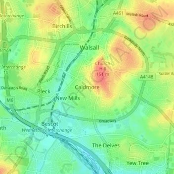
Name: Caldmore topographic map, elevation, terrain.
Average elevation: 131 m
Minimum elevation: 110 m
Maximum elevation: 160 m
Other topographic maps
Click on a map to view its topography, its elevation and its terrain.
The Swag
United Kingdom > England > Walsall > Shelfield > Stubbers Green
The Swag, Barn's Lane, Stubbers Green, Shelfield, Walsall, West Midlands Combined Authority, England, United Kingdom
Average elevation: 143 m