
Make a donation
Yabucoa topographic map
Click on the map to display elevation.
Make a donation
Yabucoa
The municipality of Yabucoa is located in the south-eastern coast of Puerto Rico. The Valley of Yabucoa is surrounded by the hills of the San Lorenzo Batholith on three sides and by the Caribbean Sea on the fourth. The hills surrounding the Yabucoa Valley as well as the bedrock underlying the alluvium in the valley are composed of the San Lorenzo Batholith, a large, igneous intrusive body emplaced during the Late Cretaceous (Rogers, 1977; Rogers and others, 1979). The San Lorenzo Batholith is a composite body that is composed of gabbro (Kd), diorite, tonalite, granodiorite, and quartz monzonite. The Cuchillas de Panduras, a fork of the Sierra de Cayey in the Cordillera Central runs through its south. Santa Elena is one of its most prominent peaks with an altitude of 1,870 feet (570 meters). Santa Elena is located in Juan Martin ward. Pandura Peak rises 1,693 feet (516 meters) above sea level. Pandura is located in the Calabazas ward. The altitude of the hills surrounding the Valley of Yabucoa reaches a maximum of about 2,130 feet (650 meters) at the head of the Río Guayanés basin. The land surface in the Yabucoa Valley slopes gently from an altitude of about 98 feet (30 meters) above mean sea level, at the western edge of the valley, to sea level where the valley meets the Caribbean Sea.
Make a donation
About this map
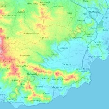
Name: Yabucoa topographic map, elevation, terrain.
Location: Yabucoa, Puerto Rico, 00767, United States (18.01135 -66.01078 18.12612 -65.79516)
Average elevation: 118 m
Minimum elevation: -2 m
Maximum elevation: 566 m
Make a donation
Other topographic maps
Click on a map to view its topography, its elevation and its terrain.