
Make a donation
Kabini topographic map
Click on the map to display elevation.
Make a donation
About this map
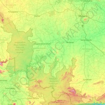
Name: Kabini topographic map, elevation, terrain.
Location: Kabini, Karnataka, India (11.80137 76.07545 12.23467 76.91387)
Average elevation: 794 m
Minimum elevation: 452 m
Maximum elevation: 1,558 m
Make a donation
Other topographic maps
Click on a map to view its topography, its elevation and its terrain.
Madikeri
India > Karnataka > Madikeri taluku
Madikeri features a tropical highland climate as it has an elevation of 1,170 m (3,840 ft). Madikeri is located at 12°25′N 75°44′E / 12.42°N 75.73°E / 12.42; 75.73. Madikeri lies in the Western Ghats and is a popular hill station. Nearest major cities are Hassan (110 kilometres (68 mi)) to the…
Average elevation: 1,054 m
Bengaluru
India > Karnataka > Bangalore North
Bangalore (/ˈbæŋɡəlɔːr, ˌbæŋɡəˈlɔːr/ BANG-gə-lor, -LOR), officially Bengaluru (Kannada: [ˈbeŋgɐɭuːɾu] ; ISO: Beṁgaḷūru), is the capital and largest city of the southern Indian state of Karnataka. It has a population of more than 8 million and a metropolitan population of around 15…
Average elevation: 879 m
Mysuru
India > Karnataka > Mysuru taluk
Mysore is situated at the foothills of the Chamundi Hills. At an altitude of 770 m (2,530 ft) above mean sea level, the city of Mysore is geographically located at 12° 18′ 26″ north latitude and 76° 38′ 59″ east longitude. It is about 140 km (87.0 mi) southwest of the state's capital, Bangalore, and…
Average elevation: 727 m
Make a donation
Harihara
India > Karnataka > Harihara taluku > Harihara
Harihara is located at 14°31′N 75°48′E / 14.52°N 75.8°E / 14.52; 75.8. It has an average elevation of 540 metres (1771 feet).
Average elevation: 545 m