
Fillol topographic map
Interactive map
Click on the map to display elevation.
About this map
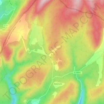
Name: Fillol topographic map, elevation, terrain.
Average elevation: 724 m
Minimum elevation: 563 m
Maximum elevation: 854 m
Other topographic maps
Click on a map to view its topography, its elevation and its terrain.
La Combe
France > Provence-Alpes-Côte d'Azur > Vaucluse > Lioux
La Combe, Lioux, Apt, Vaucluse, Provence-Alpes-Côte d'Azur, France métropolitaine, 84220, France
Average elevation: 362 m
Le Château
France > Provence-Alpes-Côte d'Azur > Vaucluse > Lioux
Le Château, Lioux, Apt, Vaucluse, Provence-Alpes-Côte d'Azur, France métropolitaine, 84220, France
Average elevation: 350 m