
Thank you for supporting this site ❤️
Make a donation
Make a donation
Midway topographic map
Click on the map to display elevation.
Thank you for supporting this site ❤️
Make a donation
Make a donation
About this map
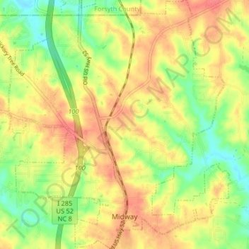
Name: Midway topographic map, elevation, terrain.
Location: Midway, Davidson County, North Carolina, United States (35.94642 -80.24885 35.99990 -80.18962)
Average elevation: 257 m
Minimum elevation: 225 m
Maximum elevation: 282 m
Thank you for supporting this site ❤️
Make a donation
Make a donation
Other topographic maps
Click on a map to view its topography, its elevation and its terrain.
Thank you for supporting this site ❤️
Make a donation
Make a donation
Jefferson Village
United States > North Carolina > Davidson County > Lexington
Average elevation: 225 m
Thank you for supporting this site ❤️
Make a donation
Make a donation