
Dhunche topographic map
Interactive map
Click on the map to display elevation.
About this map
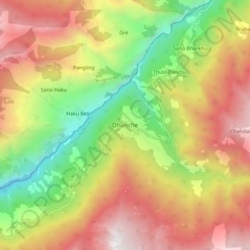
Name: Dhunche topographic map, elevation, terrain.
Location: Dhunche, Gosaikunda, रसुवा, Bagmati, Népal (28.07279 85.25606 28.15279 85.33606)
Average elevation: 2,291 m
Minimum elevation: 1,080 m
Maximum elevation: 3,527 m
Other topographic maps
Click on a map to view its topography, its elevation and its terrain.