Geolocate
👉 Easily get elevation data in JSON, GeoTIFF and KML formats using Elevation API
Thank you for supporting this site ❤️
Make a donation

Toledo topographic map

Click on the map to display elevation.

👉 Easily get elevation data in JSON, GeoTIFF and KML formats using Elevation API
Thank you for supporting this site ❤️
Make a donation

About this map

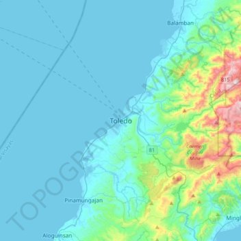
Name: Toledo topographic map, elevation, terrain.

Location: Toledo, Cebu, Central Visayas, 6038, Philippines (10.21494 123.47441 10.53494 123.79441)

Average elevation: 107 m

Minimum elevation: -2 m

Maximum elevation: 881 m

Other topographic maps

Click on a map to view its topography, its elevation and its terrain.

Bulacao River

Philippines > Cebu > Talisay

Average elevation: 3 m

Lauis Ledge Lighthouse

Philippines > Cebu > Talisay

Average elevation: 0 m

Gilutongan Island

Philippines > Cebu > Cordova > Gilutongan

Average elevation: 0 m

Logon

Philippines > Cebu

Average elevation: 1 m