
Gorno-Badakhshan Autonomous Region topographic map
Interactive map
Click on the map to display elevation.
Gorno-Badakhshan Autonomous Region
Gorno-Badakhshan covers the entire eastern part of Tajikistan and borders China's Xinjiang Uyghur Autonomous Region to the east, Afghanistan's Badakhshan Province to the south, and Kyrgyzstan's Osh Region to the north. Within Tajikistan, Gorno-Badakhshan's western border is with the Districts of Republican Subordination (DRP) and the tip of its southwestern finger (Darvoz District) borders Khatlon Region. The highest elevations in the region are in the Pamir Mountains (notably Mount Imeon), nicknamed "the roof of the world" by locals. Three of the five 7,000 meter summits in Central Asia are located here, including Ismoil Somoni Peak (formerly Communism Peak, and, before that, Stalin Peak; 7,495 m), Ibn Sina Peak (formerly Lenin Peak, and still known by that name on its Kyrgyz flank; 7,134 m), and Peak Ozodi (formerly Korzhenevskoi Peak, 7,105 m).
About this map
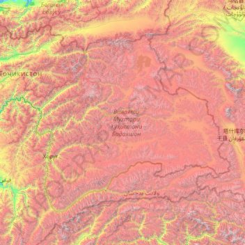
Name: Gorno-Badakhshan Autonomous Region topographic map, elevation, terrain.
Location: Gorno-Badakhshan Autonomous Region, Tajikistan (36.67112 70.25558 39.47433 75.15396)
Average elevation: 3,967 m
Minimum elevation: 1,234 m
Maximum elevation: 7,725 m
Other topographic maps
Click on a map to view its topography, its elevation and its terrain.