
Thank you for supporting this site ❤️
Make a donation
Make a donation
San Pedro topographic map
Click on the map to display elevation.
Thank you for supporting this site ❤️
Make a donation
Make a donation
About this map
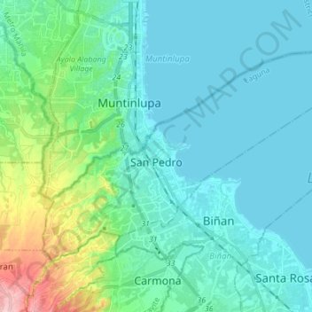
Name: San Pedro topographic map, elevation, terrain.
Location: San Pedro, Laguna, Calabarzon, 4023, Philippines (14.32153 121.00661 14.41141 121.14367)
Average elevation: 29 m
Minimum elevation: 0 m
Maximum elevation: 170 m
Thank you for supporting this site ❤️
Make a donation
Make a donation
Other topographic maps
Click on a map to view its topography, its elevation and its terrain.
Mount Banahaw and San Cristobal Protected Landscape
Philippines > Laguna > Liliw
Average elevation: 592 m
Thank you for supporting this site ❤️
Make a donation
Make a donation
Thank you for supporting this site ❤️
Make a donation
Make a donation
Thank you for supporting this site ❤️
Make a donation
Make a donation
Thank you for supporting this site ❤️
Make a donation
Make a donation
Thank you for supporting this site ❤️
Make a donation
Make a donation
Thank you for supporting this site ❤️
Make a donation
Make a donation