Geolocate

Middlesex County topographic map

Interactive map

Click on the map to display elevation.

About this map

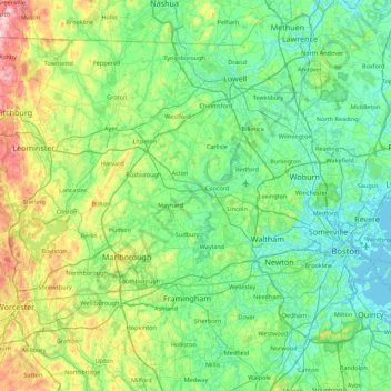
Name: Middlesex County topographic map, elevation, terrain.

Location: Middlesex County, Massachusetts, United States (42.15678 -71.89877 42.73647 -71.02038)

Average elevation: 80 m

Minimum elevation: -4 m

Maximum elevation: 391 m

Other topographic maps

Click on a map to view its topography, its elevation and its terrain.

Rockport

United States > Massachusetts > Essex County

Average elevation: 6 m

Amesbury

United States > Massachusetts > Essex County

Amesbury is located at 42°51′29″N 70°55′50″W / 42.85806°N 70.93056°W / 42.85806; -70.93056. According to the United States Census Bureau, the city has a total area of 13.7 square miles (35.5 km2), of which 12.3 square miles (31.8 km2) is land and 1.5 square miles (3.8 km2), or 10.65%, is…

Average elevation: 25 m

Boston

United States > Massachusetts > Suffolk County > Boston

Boston has an area of 89.63 square miles (232.1 km2)—48.4 square miles (125.4 km2) (54%) of land and 41.2 square miles (106.7 km2) (46%) of water. The city's official elevation, as measured at Logan International Airport, is 19 ft (5.8 m) above sea level. The highest point in Boston is Bellevue Hill at 330…

Average elevation: 26 m

Montgomery

United States > Massachusetts > Hampden County

Tekoa Mountain overlooks the Westfield River Gorge and the Connecticut River Valley. The town of Russell and its villages, Woronoco and Crescent Mills, lie at the foot of the mountain along the Westfield River. From the summit ledges, the cities of Westfield and Springfield, Massachusetts are visible to the…

Average elevation: 241 m

Belmont

United States > Massachusetts > Middlesex County

Belmont has been referred to as a "Mormon enclave" due to the location of the Boston Massachusetts Temple of the LDS Church at the highest elevation in the town. The prominent gold statue of the Angel Moroni atop the Temple was originally designed by Cyrus Dallin in nearby Arlington, Massachusetts.

Average elevation: 40 m

Truro

United States > Massachusetts > Barnstable County

The topography generally slopes downward from the Atlantic to Cape Cod Bay, and from south to north. There are several small ponds throughout town, all of which combined are smaller than the Pilgrim Lake, just east of the Provincetown town line, and just south of the sand dunes which make up most of the…

Average elevation: 3 m

Nantucket

United States > Massachusetts

Average elevation: 1 m

Somerville

United States > Massachusetts > Middlesex County > Somerville

Somerville's commercial property is not concentrated in a recognized downtown central business district but instead is spread over many different nodes or corridors of business activity. The difference in character ranges from the vibrant nightlife, live music and theaters of Davis Square to the large scale…

Average elevation: 11 m

Newburyport

United States > Massachusetts > Newburyport

Average elevation: 12 m

Wareham

United States > Massachusetts > Wareham

Wareham was first settled in 1678 by Europeans as part of the towns of Plymouth and Rochester. It was officially incorporated in 1739 and named after the town of Wareham in England. Because of its geography, Wareham's early industry revolved around shipbuilding and the related industries. It also served as a…

Average elevation: 12 m

Boston

United States > Massachusetts > Suffolk County

Boston has an area of 89.63 sq mi (232.1 km2)—48.4 sq mi (125.4 km2) (54%) of land and41.2 sq mi (106.7 km2) (46%) of water. The city's official elevation, as measured at Logan International Airport, is 19 ft (5.8 m) above sea level. The highest point in Boston is Bellevue Hill at 330 ft (100 m) above sea…

Average elevation: 25 m

Lincoln

United States > Massachusetts > Lincoln

Average elevation: 61 m

Southbridge

United States > Massachusetts > Southbridge

Average elevation: 194 m

Oakdale

United States > Massachusetts > Wareham > Oakdale

Average elevation: 6 m

Bridgewater

United States > Massachusetts > Bridgewater

Average elevation: 21 m

Haverhill

United States > Massachusetts > Haverhill

According to the United States Census Bureau, the city has a total area of 35.6 square miles (92.3 km2), of which 33.0 square miles (85.4 km2) is land and 2.7 square miles (6.9 km2), or 7.47%, is water. The city ranks 60th in the Commonwealth in terms of land area, and is the largest city or town in Essex…

Average elevation: 39 m

Newton

United States > Massachusetts > Middlesex County

Average elevation: 38 m

Hampden County

United States > Massachusetts

Average elevation: 209 m