
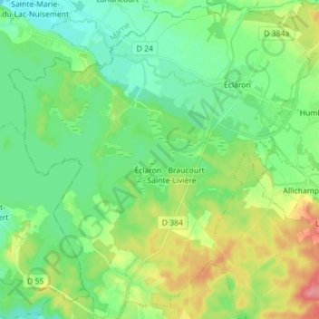
Éclaron-Braucourt-Sainte-Livière topographic map
Interactive map
Click on the map to display elevation.
About this map
Name: Éclaron-Braucourt-Sainte-Livière topographic map, elevation, terrain.
Average elevation: 149 m
Minimum elevation: 122 m
Maximum elevation: 201 m
Other topographic maps
Click on a map to view its topography, its elevation and its terrain.
Rolampont
France > Grand Est > Haute-Marne
Rolampont, Langres, Haute-Marne, Grand Est, Metropolitan France, 52260, France
Average elevation: 388 m
Nogent
France > Grand Est > Haute-Marne
Nogent, Chaumont, Haute-Marne, Grand Est, Metropolitan France, 52800, France
Average elevation: 399 m
Les Ajots
France > Grand Est > Haute-Marne > Saint-Dizier
Les Ajots, Saint-Dizier, Haute-Marne, Grand Est, Metropolitan France, 52100, France
Average elevation: 154 m
Orquevaux
France > Grand Est > Haute-Marne
Orquevaux, Chaumont, Haute-Marne, Grand Est, Metropolitan France, 52700, France
Average elevation: 385 m
Château Orquevaux
France > Grand Est > Haute-Marne > Orquevaux
Château Orquevaux, 18, Grande Rue, Orquevaux, Chaumont, Haute-Marne, Grand Est, Metropolitan France, 52700, France
Average elevation: 362 m
Auberive
France > Grand Est > Haute-Marne
Auberive, Langres, Haute-Marne, Grand Est, Metropolitan France, 52160, France
Average elevation: 417 m
Grosse-Sauve
France > Grand Est > Haute-Marne > Les Loges
Grosse-Sauve, Les Loges, Langres, Haute-Marne, Grand Est, Metropolitan France, 52500, France
Average elevation: 329 m
Leffonds
France > Grand Est > Haute-Marne
Leffonds, Chaumont, Haute-Marne, Grand Est, Metropolitan France, 52210, France
Average elevation: 382 m
Humes-Jorquenay
France > Grand Est > Haute-Marne
Humes-Jorquenay, Langres, Haute-Marne, Grand Est, Metropolitan France, 52200, France
Average elevation: 373 m
Montormentier
France > Grand Est > Haute-Marne > Cusey
Montormentier, Percey-sous-Montormentier, Cusey, Langres, Haute-Marne, Grand Est, Metropolitan France, 52190, France
Average elevation: 270 m
Joinville
France > Grand Est > Haute-Marne
Joinville, Saint-Dizier, Haute-Marne, Grand Est, Metropolitan France, 52300, France
Average elevation: 267 m
Ternat
France > Grand Est > Haute-Marne
Ternat, Langres, Haute-Marne, Grand Est, Metropolitan France, 52210, France
Average elevation: 408 m
Langres
France > Grand Est > Haute-Marne
Langres, Haute-Marne, Grand Est, Metropolitan France, 52200, France
Average elevation: 400 m