Geolocate

Nelson Mandela Bay Metropolitan Municipality topographic map

Interactive map

Click on the map to display elevation.

Nelson Mandela Bay Metropolitan Municipality topographic map, elevation, terrain

Nelson Mandela Bay Metropolitan Municipality topographic map, elevation, terrain

About this map

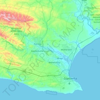
Name: Nelson Mandela Bay Metropolitan Municipality topographic map, elevation, terrain.

Location: Nelson Mandela Bay Metropolitan Municipality, Eastern Cape, South Africa (-34.05076 25.19223 -33.55308 25.86802)

Average elevation: 158 m

Minimum elevation: -1 m

Maximum elevation: 1,143 m