
Make a donation
Mianwali topographic map
Click on the map to display elevation.
Make a donation
About this map
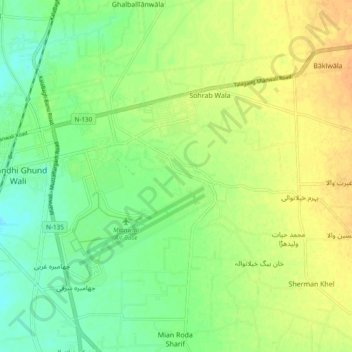
Name: Mianwali topographic map, elevation, terrain.
Average elevation: 213 m
Minimum elevation: 184 m
Maximum elevation: 721 m
Make a donation
Other topographic maps
Click on a map to view its topography, its elevation and its terrain.
Make a donation
Lalamusa
Pakistan > Punjab > Gujrat District
Lalamusa is situated on the Grand Trunk Road (National Highway 5). It is geographically located at latitude (32.7 degrees) 32° 42' 0" North of the Equator and longitude (73.96 degrees) 73° 57' 35" East of the Prime Meridian on the Map of the world and lies at an altitude of about 250 meters.
Average elevation: 254 m
Make a donation
Vehari
Vehari also spelled Vihari (وِہاڑی), is a city and the headquarters of Vehari District in the Punjab province of Pakistan. It is Pakistan's 62nd largest city. Vehari is about 100 km (62 mi) from the historical city of Multan. Vehari is located at the Multan-Delhi Road constructed by Emperor Sher Shah…
Average elevation: 139 m
Make a donation