
Thank you for supporting this site ❤️
Make a donation
Make a donation
Whitford topographic map
Click on the map to display elevation.
Thank you for supporting this site ❤️
Make a donation
Make a donation
About this map
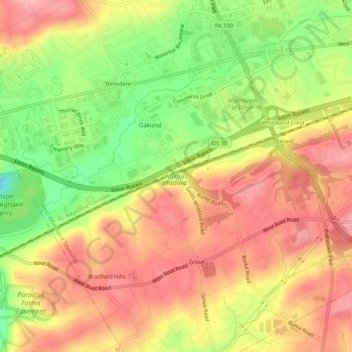
Name: Whitford topographic map, elevation, terrain.
Average elevation: 122 m
Minimum elevation: 42 m
Maximum elevation: 179 m
Thank you for supporting this site ❤️
Make a donation
Make a donation
Other topographic maps
Click on a map to view its topography, its elevation and its terrain.
Exton
United States > Pennsylvania > Chester County > West Whiteland Township > Exton
Average elevation: 118 m