
Thank you for supporting this site ❤️
Make a donation
Make a donation
Lomati topographic map
Click on the map to display elevation.
Thank you for supporting this site ❤️
Make a donation
Make a donation
About this map
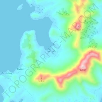
Name: Lomati topographic map, elevation, terrain.
Location: Lomati, Lau, Eastern, Fiji (-19.18410 179.73406 -19.14410 179.77406)
Average elevation: 75 m
Minimum elevation: -6 m
Maximum elevation: 380 m
Thank you for supporting this site ❤️
Make a donation
Make a donation
Other topographic maps
Click on a map to view its topography, its elevation and its terrain.
Ono-i-Lau
The group forms one of the southernmost of the Lau Islands; it is located at 20.80° South and 178.75° West, and occupies an area of 7.9 square kilometres (3.1 square miles). It has a maximum elevation of 113 metres (371 feet). It is 90 kilometres (56 mi) south-southwest of Vatoa, the nearest largish island;…
Average elevation: 5 m