Burnley topographic map
Interactive map
Click on the map to display elevation.
About this map
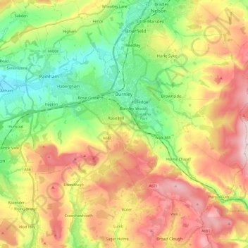
Name: Burnley topographic map, elevation, terrain.
Location: Burnley, Lancashire, England, United Kingdom (53.72300 -2.34231 53.82526 -2.11228)
Average elevation: 247 m
Minimum elevation: 63 m
Maximum elevation: 479 m
The town lies in a natural three-forked valley at the confluence of the River Brun and the River Calder, surrounded by open fields, with wild moorland at higher altitudes. To the west of Burnley lie the towns of Padiham, Accrington and Blackburn, with Nelson and Colne to the north. The centre of the town stands at approximately 387 feet (118 m) above sea level and 30 miles (48 km) east of the Irish Sea coast.
Other topographic maps
Click on a map to view its topography, its elevation and its terrain.
Lancaster
United Kingdom > England > Lancashire
Lancaster, Lancashire, England, United Kingdom
Average elevation: 84 m
Preston
United Kingdom > England > Lancashire
Preston, Lancashire, England, United Kingdom
Average elevation: 58 m
Chorley
United Kingdom > England > Lancashire
Chorley, Lancashire, England, United Kingdom
Average elevation: 113 m
Haslingden Grane
United Kingdom > England > Lancashire > Borough of Rossendale > Haslingden
Haslingden Grane, Haslingden, Borough of Rossendale, Lancashire, England, BB4 4AU, United Kingdom
Average elevation: 287 m
Longridge Fell
United Kingdom > England > Lancashire > Ribble Valley
Longridge Fell, Ribble Valley, Lancashire, England, BB7 3LY, United Kingdom
Average elevation: 218 m
Fulwood Row
United Kingdom > England > Lancashire > Preston
Fulwood Row, Preston, Lancashire, England, PR2 9PD, United Kingdom
Average elevation: 53 m
Broughton
United Kingdom > England > Lancashire > Preston
Broughton, Preston, Lancashire, England, United Kingdom
Average elevation: 43 m
Goosnargh
United Kingdom > England > Lancashire > Preston
Goosnargh, Preston, Lancashire, England, PR3 2BB, United Kingdom
Average elevation: 67 m
Hesketh Lane
United Kingdom > England > Lancashire > Ribble Valley
Hesketh Lane, Chipping, Ribble Valley, Lancashire, England, PR3 2TH, United Kingdom
Average elevation: 131 m
Mellor
United Kingdom > England > Lancashire > Ribble Valley
Mellor, Ribble Valley, Lancashire, England, United Kingdom
Average elevation: 139 m
Haggate
United Kingdom > England > Lancashire > Burnley
Haggate, Burnley, Lancashire, England, BB10 3QH, United Kingdom
Average elevation: 220 m
Catlow
United Kingdom > England > Lancashire > Borough of Pendle > Nelson
Catlow, Nelson, Borough of Pendle, Lancashire, England, BB10 3RL, United Kingdom
Average elevation: 243 m
Fold Head
United Kingdom > England > Lancashire > Borough of Rossendale > Healey
Fold Head, Whitworth, Healey, Borough of Rossendale, Lancashire, England, OL12 8XL, United Kingdom
Average elevation: 294 m
Fence
United Kingdom > England > Lancashire > Borough of Pendle
Fence, Borough of Pendle, Lancashire, England, BB12 9EE, United Kingdom
Average elevation: 187 m
Becconsall
United Kingdom > England > Lancashire > West Lancashire
Becconsall, West Lancashire, Lancashire, England, PR4 6SN, United Kingdom
Average elevation: 10 m
Lower Bartle
United Kingdom > England > Lancashire > Preston > Woodplumpton
Lower Bartle, Woodplumpton, Preston, Lancashire, England, PR4 0RX, United Kingdom
Average elevation: 30 m
Borough of Rossendale
United Kingdom > England > Lancashire
Borough of Rossendale, Lancashire, England, United Kingdom
Average elevation: 273 m
Rivington Pike
United Kingdom > England > Lancashire > Horwich
Rivington Pike, Georges Lane, Rivington, Horwich, Chorley, Lancashire, Greater Manchester, England, BL6 6RU, United Kingdom
Average elevation: 270 m
Borough of Fylde
United Kingdom > England > Lancashire
Borough of Fylde, Lancashire, England, United Kingdom
Average elevation: 13 m
White Coppice
United Kingdom > England > Lancashire > Chorley
White Coppice, Anglezarke, Chorley, Lancashire, England, PR6 9DB, United Kingdom
Average elevation: 184 m
Lancaster Canal
United Kingdom > England > Lancashire
Lancaster Canal, Lancashire, England, United Kingdom
Average elevation: 98 m
Hardhorn
United Kingdom > England > Lancashire > Borough of Wyre
Hardhorn, Borough of Wyre, Lancashire, England, FY6 8DN, United Kingdom
Average elevation: 13 m
Little Thornton
United Kingdom > England > Lancashire > Borough of Wyre
Little Thornton, Borough of Wyre, Lancashire, England, FY5 5LU, United Kingdom
Average elevation: 8 m
Silverdale
United Kingdom > England > Lancashire > Lancaster
Silverdale, Lancaster, Lancashire, England, United Kingdom
Average elevation: 16 m
Samlesbury
United Kingdom > England > Lancashire > South Ribble
Samlesbury, South Ribble, Lancashire, England, United Kingdom
Average elevation: 58 m
Arkholme
United Kingdom > England > Lancashire > Lancaster
Arkholme, Lancaster, Lancashire, England, LA6 1RA, United Kingdom
Average elevation: 57 m
Read
United Kingdom > England > Lancashire > Ribble Valley
Read, Ribble Valley, Lancashire, England, United Kingdom
Average elevation: 114 m
Stodday
United Kingdom > England > Lancashire > Lancaster
Stodday, Aldcliffe-with-Stodday, Lancaster, Lancashire, England, LA2 0AG, United Kingdom
Average elevation: 26 m
Over Kellet
United Kingdom > England > Lancashire > Lancaster
Over Kellet, Lancaster, Lancashire, England, United Kingdom
Average elevation: 69 m
Lytham St Annes
United Kingdom > England > Lancashire > Borough of Fylde
Lytham St Annes, Borough of Fylde, Lancashire, England, FY8 4AR, United Kingdom
Average elevation: 5 m
Whitewell Bottom
United Kingdom > England > Lancashire > Borough of Rossendale > Sagar Holme
Whitewell Bottom, Sagar Holme, Borough of Rossendale, Lancashire, England, BB4 9DE, United Kingdom
Average elevation: 281 m
West Lancashire
United Kingdom > England > Lancashire
West Lancashire, Lancashire, England, United Kingdom
Average elevation: 30 m
Gisburn
United Kingdom > England > Lancashire > Ribble Valley
Gisburn, Ribble Valley, Lancashire, England, United Kingdom
Average elevation: 160 m
Hayshaw Fell
United Kingdom > England > Lancashire > Lancaster
Hayshaw Fell, Over Wyresdale, Lancaster, Lancashire, England, LA2 9DW, United Kingdom
Average elevation: 226 m
Old Langho
United Kingdom > England > Lancashire > Ribble Valley > Brockhall Village
Old Langho, Billington and Langho, Brockhall Village, Ribble Valley, Lancashire, England, BB6 8AP, United Kingdom
Average elevation: 74 m
Wray-with-Botton
United Kingdom > England > Lancashire > Lancaster
Wray-with-Botton, Lancaster, Lancashire, England, United Kingdom
Average elevation: 261 m
Parlick
United Kingdom > England > Lancashire > Borough of Wyre
Parlick, Borough of Wyre, Lancashire, England, PR3 2NZ, United Kingdom
Average elevation: 251 m
Warton Crag
United Kingdom > England > Lancashire > Lancaster > Warton
Warton Crag, Trig Point to Cleft Stone, Warton, Lancaster, Lancashire, England, LA5 9NE, United Kingdom
Average elevation: 45 m
Billington and Langho
United Kingdom > England > Lancashire > Ribble Valley > Brockhall Village
Billington and Langho, Brockhall Village, Ribble Valley, Lancashire, England, United Kingdom, Chew Bank Wood
Average elevation: 58 m
Brungerley Park
United Kingdom > England > Lancashire > Ribble Valley > Clitheroe > Waddington
Brungerley Park, Clitheroe, Waddington, Ribble Valley, Lancashire, England, United Kingdom
Average elevation: 77 m
Warton Bank
United Kingdom > England > Lancashire > Borough of Fylde > Warton
Warton Bank, Bryning-with-Warton, Warton, Borough of Fylde, Lancashire, England, PR4 1TB, United Kingdom
Average elevation: 8 m
Leyland
United Kingdom > England > Lancashire > South Ribble
Leyland, South Ribble, Lancashire, England, PR25 2EX, United Kingdom
Average elevation: 41 m
Forest of Bowland AONB
United Kingdom > England > Lancashire
Forest of Bowland AONB, Lancashire, England, United Kingdom
Average elevation: 201 m
Billington
United Kingdom > England > Lancashire > Ribble Valley
Billington, Ribble Valley, Lancashire, England, BB7 9NG, United Kingdom
Average elevation: 89 m
Ewood Bridge
United Kingdom > England > Lancashire > Borough of Rossendale
Ewood Bridge, Borough of Rossendale, Lancashire, England, BB4 6LZ, United Kingdom
Average elevation: 226 m
Whitewell
United Kingdom > England > Lancashire > Ribble Valley
Whitewell, Bowland Forest Low, Ribble Valley, Lancashire, England, BB7 3AT, United Kingdom
Average elevation: 184 m
Ormskirk
United Kingdom > England > Lancashire > West Lancashire
Ormskirk, West Lancashire, Lancashire, England, L39 2XN, United Kingdom
Average elevation: 39 m
Brookhouse
United Kingdom > England > Lancashire > Lancaster
Brookhouse, Lancaster, Lancashire, England, LA2 9PA, United Kingdom
Average elevation: 82 m
Capernwray
United Kingdom > England > Lancashire > Lancaster
Capernwray, Over Kellet, Lancaster, Lancashire, England, LA6 1AE, United Kingdom
Average elevation: 60 m
Poulton-le-Fylde
United Kingdom > England > Lancashire > Borough of Wyre
Poulton-le-Fylde, Borough of Wyre, Lancashire, England, FY6 7BL, United Kingdom
Average elevation: 12 m