
Make a donation
Ojai topographic map
Click on the map to display elevation.
Make a donation
Ojai
The Ojai Valley lies within the Topatopa Mountains on the north and south and is actively shaped by a web of earthquake faults. The Sisar fault in the valley was the epicenter of a magnitude 5.1 earthquake on August 20, 2023. The Santa Ynez Mountains lie to the north, while Sulphur Mountain and the lower Black Mountain lie to the south. Nordhoff Ridge, the western extension of the Topatopa Mountains, towers over the north side of the valley at more than 5,000 feet (1,500 m). Sulphur Mountain creates the southern ranges bounding the Ojai Valley, a little under 3,000 feet (910 m) in elevation. The Sulphur and Topatopa mountains are part of the Transverse Ranges system. The Ojai Valley and the surrounding mountains are heavily wooded with oak trees.
Make a donation
About this map
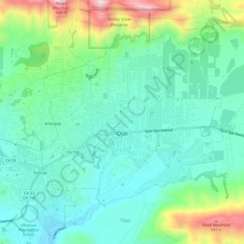
Name: Ojai topographic map, elevation, terrain.
Location: Ojai, Ventura County, California, 93023, United States (34.42924 -119.27457 34.47065 -119.22062)
Average elevation: 289 m
Minimum elevation: 180 m
Maximum elevation: 592 m
Make a donation
Other topographic maps
Click on a map to view its topography, its elevation and its terrain.