
Thank you for supporting this site ❤️
Make a donation
Make a donation
Oregon topographic map
Click on the map to display elevation.
Thank you for supporting this site ❤️
Make a donation
Make a donation
About this map
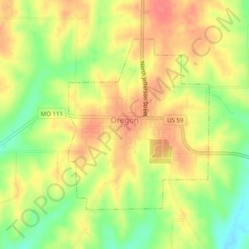
Name: Oregon topographic map, elevation, terrain.
Location: Oregon, Holt County, Missouri, United States (39.97719 -95.15293 39.99571 -95.13297)
Average elevation: 315 m
Minimum elevation: 278 m
Maximum elevation: 341 m
Thank you for supporting this site ❤️
Make a donation
Make a donation
Other topographic maps
Click on a map to view its topography, its elevation and its terrain.